Daily Read / Geography and community
Geography and community · Use cause and effect to connect a region's land features (old rock, glacier-made lakes, thin soil, forests and minerals) to how people live and work there, and sort facts into categories
What Is the Canadian Shield? Ancient Rock, Lakes and Mines
Half of Canada sits on ancient rock. Learn how glaciers shaped the Canadian Shield's lakes and thin soil, and why it means mines, forests and dams.
Device/browser voice. Pronunciation and availability vary.
Rock you can stand on
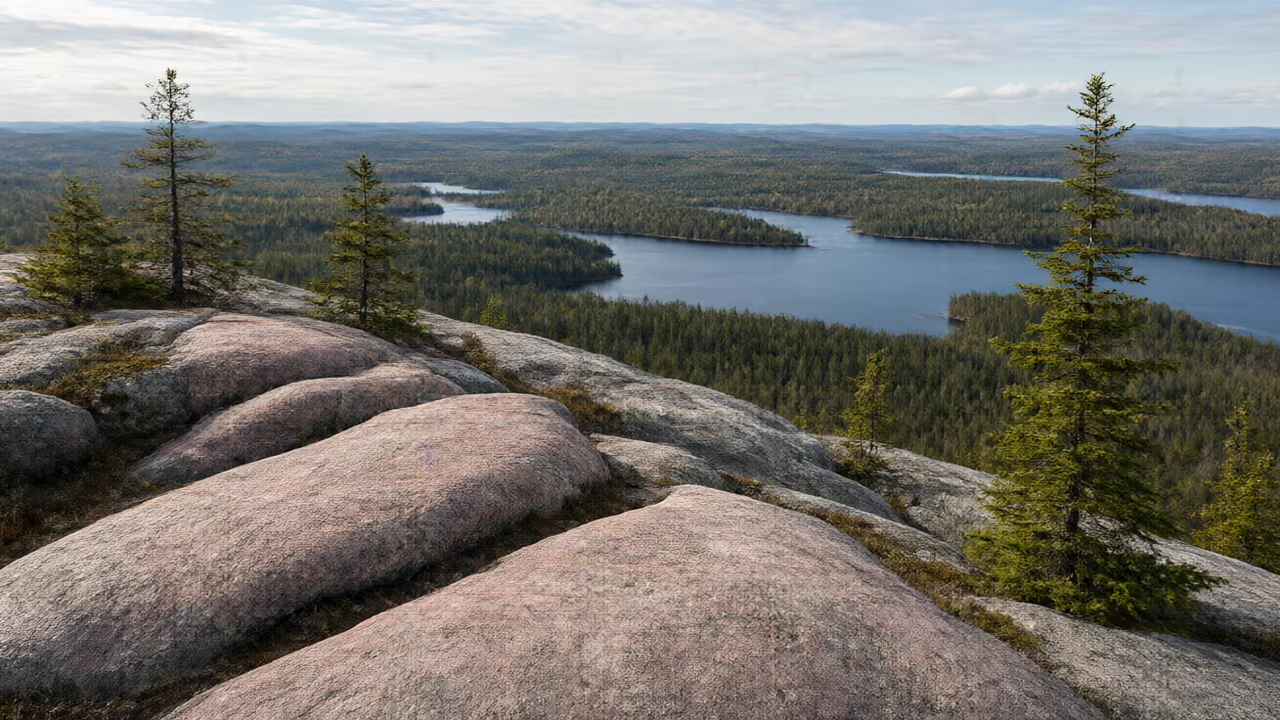
If you drive north from Toronto for a few hours, the land starts to change. Flat fields give way to pink and grey rock that pokes up beside the highway, with dark spruce and pine trees growing out of the cracks. Lakes appear around almost every bend. You have reached the Canadian Shield.
The Canadian Shield is a huge area of very old, hard rock. It covers about 5 million square kilometres, which is roughly half of all the land in Canada. That makes it the largest landform region in the country.[1]
Where is it, and why is it called a shield?
On a map, the Shield wraps around Hudson Bay. The Canadian Encyclopedia describes it as shaped like a horseshoe, or like the shields that soldiers carried long ago. It stretches across Labrador, nearly all of Quebec, much of Ontario and Manitoba, northern Saskatchewan, northeastern Alberta, and large parts of the Northwest Territories and Nunavut.
In Ontario, the Shield covers much of the province, especially the north. It reaches the northern shores of Lake Superior and Lake Huron. In 1851 and 1852, a geologist named Alexander Murray worked to map the edge of the Shield from Kingston all the way to Lake Superior.[1]
Old mountains, worn flat
The rocks you can see on the Shield are at least 1 billion years old. Some of the oldest rocks ever found on Earth are on the Shield, near the northern shore of Hudson Bay. Scientists estimate they are about 4.28 billion years old.
The Shield did not always look low and rolling. About 1 billion years ago, plates of Earth's crust pushed together and built a mountain range that may have been as big as the Himalayas are today. Over hundreds of millions of years, wind, water and ice wore those mountains down. Geologists estimate that tens of kilometres of rock were worn away. Today, the Shield has rolling hills instead of tall peaks.[1]
What the glaciers left behind
During the last ice age, a giant sheet of ice covered the Shield. In some places it was up to 3 km thick. As the ice slowly moved, it scraped the rock like sandpaper. It scratched long lines into the rock and carved out hollows.
The ice began to melt and pull back about 11,000 years ago. Water filled many of the hollows the ice had carved. According to The Canadian Encyclopedia, the Shield's lakes are largely the result of glacial erosion during the last ice age. That is why there are thousands of lakes on the Shield.
The soil on the Shield is thin, and in many places bare rock shows through. Land like this is rocky and poor for farming. The Encyclopedia's plain-language summary says that most European settlers avoided the Shield because of its poor soil, and that few people live directly on it.[1]
Forests, rocks and rivers: how people use the Shield
Thin soil is not good for crops, but trees can grow there. Much of the Shield is covered by boreal forest, with trees such as spruce and pine. Forestry is a major industry, and many small towns in northern Ontario and Quebec grew up around pulp and paper mills.
The old rocks of the Shield also hold valuable minerals. Near Sudbury, Ontario, miners dig for nickel and copper. The Encyclopedia says the Sudbury area has the largest concentration of active mines on the Shield and in the world. Gold was found at Kirkland Lake in 1906 and at Timmins in 1912. Silver was found at Cobalt, Ontario, in 1903, but the town no longer has active mines.
The Shield's many rivers and lakes are useful too. Falling water can turn turbines to make electricity, so the Shield is a major source of hydroelectricity. Some of the biggest dams in Canada are on the Shield, including Churchill Falls in Labrador and the James Bay projects in Quebec.[1]
People of the Shield
Indigenous peoples have lived on the Shield for thousands of years. The traditional territories of many nations are on the Shield, including the Cree, Anishinaabeg, Métis, Innu, Dene and Inuit. The forests are home to animals such as moose, black bears, beavers, wolves, lynx and caribou. Fish such as trout and northern pike live in the lakes and rivers.
Today, the Shield is home to Indigenous communities as well as mining towns and forestry towns. The next time you see a big slab of pink rock beside a northern highway, you will know you are looking at some of the oldest land on Earth.[2]
Fast lesson
Use these checks before you answer the practice questions.
Look at a map of Canada together and trace the horseshoe shape around Hudson Bay. Then find Sudbury, Timmins and Lake Superior. Ask: is Toronto on the Shield? (The article says you reach it by driving north.)
Have your child connect each land feature to a use with the word 'so': thin soil, so poor farming; many rivers, so hydroelectricity; old rock with minerals, so mining.
Write 1 000 000 000 and count the zeros together. Explain that a billion is a thousand millions. Then compare: the oldest rocks (about 4.28 billion years) and the glaciers melting (about 11,000 years ago).
Point out the sentence that says few people live directly on the Shield. Ask why it matters that the word is 'few' and not 'no one'.
Common mistakes
Why this fails: Most of the Shield's lakes were carved by glaciers during the last ice age; dams were built later on rivers that were already there.
Why this fails: Indigenous peoples have lived there for thousands of years, and today it has Indigenous communities, mining towns and forestry towns.
Why this fails: 5 million square kilometres measures area; 1 billion and 4.28 billion years measure age. Check the unit after each number.
Word Lab
Use the meaning, hear the word, then try it in your own sentence.
Canadian Shield
proper nouna huge region of very old, hard rock that covers about half of Canada and wraps around Hudson Bay
Sudbury is on the Canadian Shield.
landform region
noun phrasea large area where the land has similar features, such as rock, hills or plains
The Shield is Canada's largest landform region.
glacier
nouna very large, slow-moving mass of ice
A glacier scraped the rock and carved hollows.
erosion
nounthe slow wearing away of rock or soil by water, wind or ice
Erosion wore the old mountains down.
ice age
noun phrasea long time when ice sheets covered large parts of Earth
During the last ice age, ice up to 3 km thick covered the Shield.
mineral
nouna natural solid material found in rock, such as nickel, copper, gold or silver
The Shield's rocks hold valuable minerals.
mining
noundigging into the ground to take out minerals
Mining is an important job in Sudbury.
boreal forest
noun phrasea northern forest made up mostly of trees such as spruce and pine
Much of the Shield is boreal forest.
forestry
nounthe work of growing, caring for and cutting trees for wood and paper
Forestry towns grew up around paper mills.
hydroelectricity
nounelectricity made by using moving water to turn machines
The Shield's rivers make a lot of hydroelectricity.
traditional territory
noun phraseland that an Indigenous nation has lived on and used for a very long time
Cree and Anishinaabeg traditional territories include parts of the Shield.
billion
nounone thousand million (1 000 000 000)
The Shield's rocks are at least 1 billion years old.
Check your understanding
Choose an answer, explain your choice, and then check. Hints and retries are welcome.
Try the questions here. Public practice does not save a learning record.
Support · Find it in the text
Support · Find it in the text practice
Each answer is stated in the article. Point to the sentence.
1. About how much of Canada's land does the Shield cover?
2. Which large body of water does the Shield wrap around?
3. How old are the rocks you can see on the Shield?
4. How thick was the ice in some places during the last ice age?
5. Which two minerals are mined near Sudbury?
6. Name three Indigenous peoples whose traditional territories are on the Shield.
Apply · Land and people
Apply · Land and people practice
Connect each land feature to how people use it.
7. Explain why the Shield has thin soil and lots of bare rock.
8. Thin soil is bad for crops. What grows well on the Shield instead, and what job does that create?
9. Why are there mining towns such as Sudbury and Timmins on the Shield?
10. Why did the Shield's high mountains turn into low, rolling hills?
11. Why is it called a 'shield'?
12. Silver was found at Cobalt in 1903 and gold at Timmins in 1912. How many years apart were these discoveries?
Reason · Chains and categories
Reason · Chains and categories practice
Build cause chains and sort the facts.
13. Build a cause chain with four links that starts with 'ice sheet covers the Shield' and ends with 'thousands of lakes'.
14. Sort into Land, Water or People: boreal forest, Churchill Falls, Sudbury mines, thousands of lakes, thin soil, pulp and paper mills.
15. The article says the Shield is poor for farming but rich in minerals. Explain how both can be true.
16. A classmate says, 'Nobody lives on the Shield.' Use the article to correct this.
17. Cobalt, Ontario, no longer has active mines. Why might a mining town change when the minerals run out?
Practice answer key
- 1. Roughly half (about 5 million square kilometres).
See 'Rock you can stand on'. - 2. Hudson Bay.
See 'Where is it, and why is it called a shield?'. - 3. At least 1 billion years old.
See 'Old mountains, worn flat'. - 4. Up to 3 km thick.
See 'What the glaciers left behind'. - 5. Nickel and copper.
See 'Forests, rocks and rivers'. - 6. Any three of: Cree, Anishinaabeg, Métis, Innu, Dene, Inuit.
See 'People of the Shield'. - 7. Glaciers scraped across the rock during the last ice age, and the soil on the Shield is thin, so in many places bare rock shows through.
Follow the glacier story in the article. - 8. Forests of trees such as spruce and pine grow there, which supports forestry and pulp and paper mills.
One feature can rule out one use but allow another. - 9. The Shield's old rocks hold valuable minerals such as nickel, copper and gold, so towns grew where miners dug for them.
Resources in the land bring jobs. - 10. Over hundreds of millions of years, wind, water and ice wore the mountains down by erosion.
Erosion works slowly but over a very long time. - 11. On a map it is shaped like a horseshoe, or like the shields soldiers carried long ago.
The name describes its shape. - 12. 9 years (1912 − 1903 = 9).
Subtract the earlier year from the later year. - 13. Ice sheet covers the Shield → the moving ice carves hollows in the rock → the ice melts about 11,000 years ago → water fills the hollows, making thousands of lakes.
Each link should cause the next. - 14. Land: boreal forest, thin soil. Water: Churchill Falls, thousands of lakes. People: Sudbury mines, pulp and paper mills.
Some facts could fit two groups; explain your choice. - 15. Farming depends on deep soil on top of the land, while minerals are found in the rock itself. The Shield has thin soil but very old rock that holds metals.
Different uses depend on different parts of the land. - 16. Indigenous peoples have lived there for thousands of years, and today there are Indigenous communities, mining towns and forestry towns. The article says few people, not no people, live directly on it.
Notice the difference between 'few' and 'none'. - 17. Answers will vary: mining jobs may end, so some people may move away or the town may need new kinds of work.
This is a reasoned prediction, not a fact from the article.
Related skills
Put it in your own words
This draft is not saved when you leave or refresh the page.
Check your own explanation
This is self-review, not automatic marking.
Compare with a model response
The Canadian Shield is a huge region of old, hard rock that covers about half of Canada and wraps around Hudson Bay. Much of northern Ontario is on the Shield. The rocks you can see there are at least 1 billion years old. During the last ice age, a glacier up to 3 km thick scraped the rock and carved hollows, so when the ice melted, water filled them and made thousands of lakes. The soil is thin, so the land is poor for farming. However, boreal forest grows well there, and as a result forestry and paper mills are important. The old rocks also hold minerals, so towns such as Sudbury and Timmins grew up around mines. Because the Shield has so many rivers, it is also a major source of hydroelectricity.
Sources and revision notes
Source check: 2026-11-02. Grade guidance is an editorial suggestion, not a standardised reading score.
- The Canadian Encyclopedia — Canadian Shield
- The Canadian Encyclopedia — Canadian Shield (Plain-Language Summary)
What changed in this edition?
Facts from The Canadian Encyclopedia's Canadian Shield article: about 5 million km² and roughly 50 per cent of Canada's land mass; horseshoe or shield shape; extent across Labrador, Quebec, Ontario, Manitoba, Saskatchewan, Alberta, the Northwest Territories and Nunavut; northern shores of Lake Superior and Lake Huron; Alexander Murray mapping the perimeter from Kingston to Lake Superior in 1851–52; exposed rocks at least 1 billion years old; rocks near Hudson Bay estimated at 4.28 billion years; the Grenville mountains about 1 billion years ago comparable to the Himalayas; tens of kilometres of rock eroded; ice up to 3 km thick; retreat beginning about 11,000 years ago; lakes largely the result of glacial erosion; striations; thin soils; boreal forest and forestry towns around pulp and paper mills; Sudbury's nickel and copper and its concentration of active mines; Kirkland Lake gold (1906), Timmins gold (1912), Cobalt silver (1903) and no active mines at Cobalt today; hydroelectricity including Churchill Falls and James Bay. The plain-language summary supports: rocky land poor for farming, few people living directly on the Shield, settlers avoiding its barren soil, Indigenous peoples living there for thousands of years and the named nations, and the animals and fish listed. The opening drive north from Toronto, the pink and grey rock description and 'like sandpaper' are this lesson's descriptive framing; 'the largest landform region' follows from it covering about half of Canada. Questions e05 and f01–f04 ask for reasoned predictions beyond the sources.