Daily Read / Ontario geography
Ontario geography · Explain how the Niagara Escarpment formed through erosion of hard and soft rock, locate where it runs in Ontario, and describe who lives on and cares for the land along it
What Is the Niagara Escarpment? Ontario's Long Rocky Ridge
A rocky ridge runs 725 km from Niagara to the Bruce Peninsula. Learn how hard caprock and soft shale made its cliffs, and who cares for the land along it.
Device/browser voice. Pronunciation and availability vary.
A ridge you may have driven past
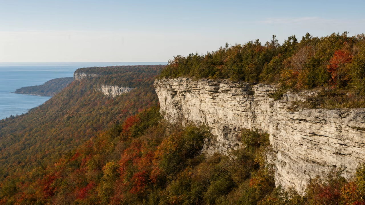
If you have driven from Toronto toward Hamilton or Niagara Falls, you may have seen it: a long, steep, rocky edge rising above the flat land near Lake Ontario. In some places it looks like a wall of grey stone with trees growing along the top. This is the Niagara Escarpment.
An escarpment is a long cliff or steep slope that separates higher land from lower land. The Niagara Escarpment Commission, an agency of the Ontario government, says the escarpment spans 725 kilometres from the tip of the Niagara Region to the top of the Bruce Peninsula. It also describes the escarpment as more than 450 million years old.[2]
Hard rock on top, soft rock below
How does a cliff that long form? An archived article from the University of Waterloo's Earth sciences publication, Wat On Earth, explains that the escarpment was made by differential erosion. That means weather and streams wore away rocks of different hardness at different speeds.
On top of the escarpment sits a caprock of dolostone, a hard rock that resists wearing away. Underneath are weaker shale rocks that erode more easily. Streams removed the softer shale and undercut the hard caprock, until the hard layer was left standing as a cliff. The article says this took millions of years.
Here is a simple way to picture it, with an invented model. Put a hard cracker on top of a stack of soft cake, then drip water on the side. The cake washes away first, and the cracker edge sticks out. Rock is much slower, but the idea is similar: the hard layer on top protects the soft layer under it until the soft layer is worn away from the side.[1]
Not a crack in the Earth
Some people guess that a long cliff must mark a place where the ground cracked and one side slid down. The Wat On Earth article says the Niagara Escarpment is not formed by faulting. The rock layers were not pushed up or dropped down. Erosion did the work.
The article says the erosion is most easily seen at Niagara Falls, where the fast-moving river speeds up the process. The Niagara River pours over the hard caprock and wears away the soft rock underneath. In the Daily Read on the Great Lakes, you learned how the lakes are connected. The Niagara River is one of those connections, carrying water from Lake Erie toward Lake Ontario, and it crosses the escarpment at the falls.[1]
From Niagara to the Bruce and beyond
In Ontario, the escarpment runs north from the Niagara River, curves past Hamilton and up through the hills west of Toronto, and then forms the spine of the Bruce Peninsula, which separates Georgian Bay from the main part of Lake Huron.
The Wat On Earth article explains that the escarpment does not stop in Ontario. It continues through Manitoulin Island and other islands in northern Lake Huron, and it can be traced into northern Michigan. It also stretches into New York State and Wisconsin, roughly circling a large bowl of rock under the state of Michigan.[1]
People and the land
At the northern end of the escarpment is Bruce Peninsula National Park. Parks Canada describes towering cliffs of the Niagara Escarpment plunging into the blue waters of Georgian Bay. Parks Canada also says the park is in the traditional territory of the Saugeen Ojibway Nation, the traditional keepers of the Saugeen (Bruce) Peninsula.
On another page about the park, Parks Canada calls it the traditional home of the Saugeen Ojibway Nation and says the Nation has long depended on the land for food and spiritual life. The same page lists cliffside cedars and limestone coasts among the park's natural features.[3]
Protecting a long, narrow place
Because the escarpment is so long and passes through cities, farms and forests, Ontario created a special agency for it. The Niagara Escarpment Commission says the Ontario government established it in June 1973. It is a regulatory agency that manages development on the escarpment and applies the policies of the Niagara Escarpment Plan. For example, people who want to build in the plan area may need a permit from the Commission.
The Commission describes the escarpment as a UNESCO World Biosphere. A biosphere reserve is a place recognized for protecting nature while people continue to live and work there. Parks Canada also says Bruce Peninsula National Park is part of a UNESCO World Biosphere Reserve.
The escarpment is also a place to explore. The Commission says it is home to Canada's longest footpath, the Bruce Trail. Many families walk short sections of the trail to see the cliffs, the views and the forest along the top of the ridge.[2]
Fast lesson
Use these checks before you answer the practice questions.
Ask your child to explain the escarpment in four words: hard on top, soft below. Then ask what water does to each layer.
Open an online map and follow the escarpment from Niagara Falls past Hamilton to Tobermory. Seeing the route helps the 725 km number make sense.
Use the article's wording: traditional territory and traditional keepers of the peninsula. Encourage your child to name the Saugeen Ojibway Nation correctly.
The section on the Commission explains what it does. Building and protection decisions can involve different views; this lesson describes the process without taking a side.
Common mistakes
Why this fails: The source says it is not formed by faulting; erosion of soft rock under hard rock made the cliff.
Why this fails: The hard dolostone caprock is on top; the softer shale is underneath.
Why this fails: It runs 725 km in Ontario and continues into the United States.
Word Lab
Use the meaning, hear the word, then try it in your own sentence.
escarpment
nouna long cliff or steep slope that separates higher land from lower land
The Niagara Escarpment runs 725 kilometres across southern Ontario.
ridge
nouna long, narrow, raised strip of land
A rocky ridge runs from Niagara to the Bruce Peninsula.
erosion
nounthe slow wearing away of rock or soil by water, wind or ice
Erosion by streams formed the cliffs.
caprock
nouna hard layer of rock on top of softer rock
The dolostone caprock protects the shale underneath.
dolostone
nouna hard rock, similar to limestone, that wears away slowly
The top of the escarpment is dolostone.
shale
nouna soft rock made of layers of mud that breaks and wears away easily
The shale under the caprock eroded first.
undercut
verbto wear away the rock underneath something
Streams undercut the hard caprock.
peninsula
nounland that is almost surrounded by water
The Bruce Peninsula separates Georgian Bay from Lake Huron.
traditional territory
noun phraseland that an Indigenous Nation has lived on and cared for over a very long time
Bruce Peninsula National Park is in the traditional territory of the Saugeen Ojibway Nation.
biosphere reserve
noun phrasea place recognized for protecting nature while people live and work there
Parks Canada says the park is part of a UNESCO World Biosphere Reserve.
agency
nounan organization that does a special job for a government
The Niagara Escarpment Commission is an agency of the Ontario government.
permit
nounan official paper that gives permission to do something
Some builders need a permit from the Commission.
Check your understanding
Choose an answer, explain your choice, and then check. Hints and retries are welcome.
Try the questions here. Public practice does not save a learning record.
Support · Find it in the text
Support · Find it in the text practice
Each answer is stated in the article. Point to the sentence.
1. How long is the Niagara Escarpment, according to the Niagara Escarpment Commission?
2. What hard rock forms the caprock?
3. Where does the article say erosion is most easily seen?
4. Name one place outside Ontario where the escarpment continues.
5. Whose traditional territory is Bruce Peninsula National Park in?
6. When did the Ontario government establish the Niagara Escarpment Commission?
Apply · Rock, water and people
Apply · Rock, water and people practice
Explain how the cliffs formed and why the land matters.
7. Finish the sentence: The shale wore away first because …
8. Finish the sentence: Streams undercut the caprock, so …
9. Why is "differential erosion" a good name for how the escarpment formed?
10. Why does the Niagara River speed up erosion at the falls?
11. What is a biosphere reserve?
12. The escarpment is more than 450 million years old, and the Commission was created in 1973. Which number describes the rock, and which describes people's actions?
Reason · Chains and sources
Reason · Chains and sources practice
Build cause chains and think about evidence.
13. Put in order: cliff stands · streams wear away shale · hard caprock sits on soft shale · caprock is undercut.
14. Is "The escarpment is not formed by faulting" a fact from a source or the article's invented model?
- A fact from a source
- The invented model
15. The cracker-and-cake model is invented. What does it show well, and what does it not show?
16. How is the escarpment's story like the Great Lakes' story from an earlier Daily Read?
17. The Wat On Earth article was first published in 1996. Why is it still useful, and what might you check?
Practice answer key
- 1. 725 kilometres.
See 'A ridge you may have driven past'. - 2. Dolostone.
See 'Hard rock on top, soft rock below'. - 3. At Niagara Falls.
See 'Not a crack in the Earth'. - 4. Northern Michigan, New York State or Wisconsin.
See 'From Niagara to the Bruce and beyond'. - 5. The Saugeen Ojibway Nation.
See 'People and the land'. - 6. June 1973.
See 'Protecting a long, narrow place'. - 7. … it is a weaker rock that erodes more easily than dolostone.
Different hardness means different speeds of erosion. - 8. … the hard layer was left standing as a cliff.
This is the last step of the process. - 9. Because the rocks wore away at different speeds; differential means different.
The name describes the cause. - 10. Because fast-moving water pours over the edge and wears away the soft rock under the caprock.
See the Niagara Falls paragraph. - 11. A place recognized for protecting nature while people continue to live and work there.
See the protection section. - 12. 450 million years describes the age of the rock; 1973 describes when people created the Commission.
Rock time and human time are very different scales. - 13. Hard caprock sits on soft shale → streams wear away shale → caprock is undercut → cliff stands.
Each step causes the next. - 14. A fact from a source
It comes from the University of Waterloo article. - 15. It shows hard material protecting soft material; it does not show the real time scale or real rock.
Models simplify reality. - 16. Both were shaped by natural forces wearing away or carving rock over a very long time.
Connecting lessons builds a bigger picture of Ontario's land. - 17. Rock formation does not change quickly, so the explanation is still useful; you could check newer sources for updated details.
Older sources can be reliable for slow-changing topics, but it is wise to cross-check.
Related skills
Put it in your own words
This draft is not saved when you leave or refresh the page.
Check your own explanation
This is self-review, not automatic marking.
Compare with a model response
The Niagara Escarpment is a long, rocky ridge that runs about 725 kilometres from Niagara to the Bruce Peninsula. On top is a hard rock called dolostone, and underneath is a softer rock called shale. Because the shale is weaker, weather and streams wore it away faster. As a result, the hard caprock was undercut and left standing as a cliff. This is called differential erosion, and it is easiest to see at Niagara Falls. The escarpment is not a crack in the Earth, so faulting did not make it. At the northern end, Bruce Peninsula National Park is in the traditional territory of the Saugeen Ojibway Nation.
Sources and revision notes
Source check: 2026-11-04. Grade guidance is an editorial suggestion, not a standardised reading score.
- University of Waterloo, Wat On Earth (archived 1996 article) — What is the Niagara Escarpment?
- Niagara Escarpment Commission — About
- Parks Canada — Bruce Peninsula National Park
- Parks Canada — Bruce Peninsula National Park: Stewardship and management
What changed in this edition?
The formation of the escarpment by differential erosion of rocks of different hardness by weather and streams, the dolostone caprock over weaker shale, undercutting until the caprock stands as a cliff, the statement that it is not formed by faulting, Niagara Falls as the place where erosion is most readily seen, and the route through the Bruce Peninsula, Manitoulin and islands in northern Lake Huron into northern Michigan, New York State and Wisconsin come from the University of Waterloo Wat On Earth article (dated 1996, archived). The 725-kilometre length from the Niagara Region to the Bruce Peninsula, the age of more than 450 million years, the June 1973 establishment of the Commission, its role as a regulatory agency that manages development and applies Niagara Escarpment Plan policies, the UNESCO World Biosphere description and the Bruce Trail as Canada's longest footpath come from the Niagara Escarpment Commission. The cliffs plunging into Georgian Bay and the traditional territory and traditional keepers wording come from the Parks Canada park home page; the traditional home wording, dependence on the land for food and spiritual life, the UNESCO World Biosphere Reserve statement, cliffside cedars and limestone coasts come from the Parks Canada stewardship page. The general definitions of escarpment and biosphere reserve, the drive-past scene, the permit example, the description of the route past Hamilton and west of Toronto, the Niagara River flowing from Lake Erie toward Lake Ontario, the cracker-and-cake model and the home activity are this lesson's explanations or illustrations. Report errors through Sources and corrections.